 USING GPS DATA TO IMPROVE
PERFORMANCE
By Mike Burrell
Probably every one of our readers has used some sort of GPS device. After all, we all have to get to the track and no one buys an atlas anymore do they? The newer smart phones have GPS built in, and my wife runs with a GPS module that traces here route, distance, and speed. But a small percentage of karters are joining the Indycar, F1, and other professional racers and using GPS technology to improve our racing and kart setups.
In professional motorsports, GPS is used to create the Sportvision© graphics you see during the broadcasts. The “pointer” used in NASCAR and Indycar to show the car’s position on the track and speed is generated by the same Honeywell GPS system used on the Navy’s Tomahawk missiles. This system is accurate to within 2cm, and Indycar teams can buy the data from the system to overlay the driver’s lines with pinpoint accuracy. But the system is $20,000 and you would have to have Defense Department security clearance to buy it. Fortunately, there are much more affordable GPS systems available for karting!
Earlier this summer, I needed a new toy and bought an AIM GPS05 system. I had tested an earlier version of the AIM GPS system, and have to say I wasn’t real impressed. However, like everything else in the world of electronics that is constantly improving, the GPS05 is a very effective data acquisition tool.
The AIM GPS05 system comes with the GPS module and a two-port data hub that allows you to use the GPS module simultaneously with the E-box. The data hub also has power wires to use an external battery to power the data system. However, should one chose not to use an E-box, the data hub is not necessary. The GPS05 module will plug directly into the MyChron4 dash and run off the dash’s internal nine volt battery (take a spare battery though, the power usage increases greatly).
No matter which way one chooses to hook up the AIM GPS05 system (with or without E-box), it is essential to have the latest GPS firmware installed on the MyChron4 unit. All AIM software is available on their website and is free: download it onto a data key and install onto the MyChron4 (once the data key is installed to the “EXP” slot on the dash, turn the dash on, and it will automatically update).
Once the correct GPS firmware is loaded onto the MyChron4 and the GPS05 unit is hooked up, there should be a “VIEW” setting on the dash that displays the GPS speed and the number of satellites the GPS module sees. Depending the cloud cover, other atmospheric interference, and one’s position the number of satellites will vary. Generally, the more satellites the better the accuracy.
It is also from this screen that the user can set a start/finish line for the GPS system to use for lap timing, thereby negating the need for the infrared beacon receiver on the kart and transmitter placed trackside.
The first step is to enter the MyChron4 dash settings and change the beacon from infrared to GPS. This will activate the functions at the bottom of the GPS view page. Follow the instructions at the bottom of the GPS VIEW screen, after a couple of clicks “OK” the GPS start/finish line for that track is permanently stored on that dash. This can even be done without the kart running, so before practice even starts it’s advisable to roll the kart out to your desired start/finish position and establish it; you do have to remember to change the track name in the MyChron4 dash settings. Once that “beacon” point is set, the MyChron4 will remember that GPS position every time you come back to that track. For those of us who have left a beacon transmitter at every track across the country, this is a Godsend!
Installing the GPS05 system is easy. Using high-strength Velcro and/or ty-wraps, mount the module to the column fairing or somewhere it is safe and has an unobstructed view of the sky. Then, either plug the GPS module directly into the dash or the data hub. If using the data hub and an external battery, you will also have to mount it to the kart and wire the power cord to the battery. The power cord is plenty long to mount the data hub on or near the column fairing and run the power cords to a frame mounted battery like a TAG or Rotax would use.
After installed and hooked up, turn the MyChron4 dash on for a few minutes and allow it to find some satellites. If on the GPS VIEW page where it shows “N. Sat” (number of satellites the system sees) as one or more, the system is ready to start logging!
After an on-track session, the GPS data is downloaded the same way as E-box data via AIM’s USB download key. But the GPS data greatly increases the amount of valuable information one can evaluate in the Race Studio Analysis software – and this is where the performance advantage is!
GPS Data Evaluation
With Race Studio analysis open, the “GPS” icon across the top of the screen will be active if GPS data is present and the system is functioning normally. However, before beginning any data analysis, one must make a functioning track map. Fortunately, the AIM GPS system makes this much easier than it was in the past with speed, beacon, and lateral G sensors.
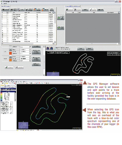
Assuming the track map is saved and applied to this data set, one of the first items to evaluate is the GPS data by clicking the “GPS” icon that is across the top of the screen. This will bring up an overhead GPS view of the track that is colored in the whole blue to red spectrum. At the left in the measures bar, it will tell the user what channel this spectrum represents (engine, speed, temperature, etc.); click on any of the colors in the measures bar to change the channel and ranges represented by the colors.
With the GPS speed as the selected channel, one can easily see where the kart is accelerating and decelerating and minimum and maximum speeds. By zooming into a specific corner, there are some assumptions the tuner can make about the kart’s handling or driver’s performance. For example, under heavy braking the color will probably change from red to blue in a short distance. In mid-corner, the color should be blue (the slowest point of the corner). If it starts to fade to a lighter blue, implying speed is gaining, and then goes back to the darker blue (slower), either the driver is accelerating too early and the chassis breaks traction requiring the driver to decelerate.
For more detail in a specific corner, run the mouse over any point of the track and it will tell you the specific reading for the selected channel. This can be especially valuable when evaluating the minimum RPMs or speeds for clutch and gear setting.
With the GPS page, one can overlay multiple laps from the session or even different drivers. If the lines cross often, the user can tell a lot about the drivers’ styles; for example, one driver might drive in deeper and “diamond” off the corner versus another driver who goes in easier and “rolls” the corner.
There is also a “front view” as if you are standing at the beacon looking due north and laying level with the track. This view is valuable for evaluating gear ratios and engine tuning on a track that has drastic elevation changes. The three tracks used for data samples in this story, NCMP, Daytona’s infield sprint track and Orlando Kart Center, are nearly flat and this feature seems to have little value.
The GPS data page also allows for overlapping of multiple laps. By overlapping multiple laps, one can explore –with an acceptable amount of accuracy different driving lines and how they effect the cornering speeds.
For example, looking at the screenshot of the right hand hairpin at the end of Orlando Kart Center’s long straight we can see the difference in two laps. Lap one uses an inside line and lap two uses a wider outside line. Running the cursor over each lap trace shows the speed at varying points around the corner; remember, any parameter the GPS and MyChron4 displays can be compared here (RPM, speed, G-forces, etc.). What we learned from this was the outside/higher line all the way around the corner was faster.
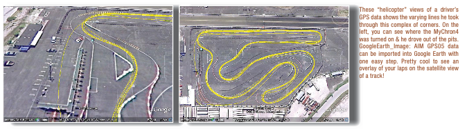
A complete session can be exported to Google Earth and overlaid with a satellite image of the track. Google and the AIM exported KML file automatically calculate this. The less laps in a session the better for comparing driving lines; we found that Race Studio even exports “Disabled” laps to the KML file, making it very cluttered. However, there is some value to this overlay: one can evaluate the consistency of their driving.
Each lap is displayed on the Google Earth map by yellow lines, so there is no differentiation to tell which lap is which. The accuracy is very good, especially considering the cost of the AIM GPS05 versus other GPS units; in our sample export, there was only one straightaway/corner that showed us driving off the track out of eight laps.
Generally, the Google Earth overlay can tell the user if there is a lap (or two) that use a significant driving line variation; then the user can go into the Race Studio analysis page and evaluate the GPS data (lap by lap) in greater detail to see if the alternative line is faster or slower. Also, this overlay can be manipulated to show the overlay at an angle (like if you were looking out the windshield of a helicopter). This “birds eye view” of the track can help the driver recall where he/she passed karts, tried different lines, or made mistakes that cost them time.
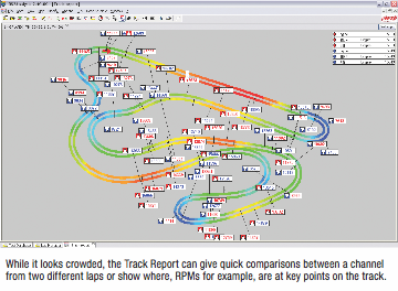
Another added feature in Race Studio for the evaluation of GPS data is the Track Report. The Track Report uses the GPS color spectrum for a particular channel from one or more laps along with ‘markers’ at key points on the track with that channel’s reading. With two laps selected (from the same session), one can drag the cursor to certain spots on the track and view the RPMs at that spot for both selected laps. This could give the user insights into why/where a particular lap was good or bad and if the gearing is correct.
The Track Report is also very valuable with evaluating the handling of the kart. By looking at the lateral and linear G-Forces, the tuner can interpolate how the chassis is handling compared to other runs. Lateral G’s will show if and where in the corner the kart might be loosing traction and linear G’s will show braking forces and acceleration.
Finally, another of Race Studio’s newest and most helpful functions for driver evaluation is the Lap Replay feature. This feature will work with data from either GPS or the E-box. For showing a driver (young drivers especially) where they are losing time on the track, Lap Replay is one of the most helpful tools in Race Studio because it looks like a video game. Lap Replay allows the user to simulate two laps (from the same or different sessions) on the screen simultaneously; essentially, two dots –one representing each lap, race around the track map.
On the bottom of the screen are “Start/Stop” and forward/reverse buttons. Just above these buttons are “Distance” and “Time Diff” logs comparing laps one and two. These tell the user how far ahead (or behind) in feet and seconds lap one is compared to lap two. Can you believe nineteen feet difference is over .2 second?
On the right of the Lap Replay screen is where the user can select the laps they want to compare and select two data parameters to monitor in real time (most often this will be RPM and Speed). Watching all of this data and the “racing dots” together gives clues as to where one driver is losing time to another and helps answer those proverbial questions: “am I overdriving”, “am I down on horsepower”, and more.
AIM also has GPS Manager software available to make working with the GPS data and system easier. With GPS Manager lap times can be recorded without any previous operation, leaving old systems out: neither infrared or magnetic beacons nor track inspections before tests. GPS Manager allows lap and split beacons to be communicated directly to the MyChron4.
GPS Manager allows the user to create, import, export, and modify tracks. The software uses one of two file types to create the map: the GPK file (for users with GPS data) and the KMB file type (for users of the Smarty Cam).
Creating the track with data from the MyChron4, I was able to take a track map of New Castle Motorsports Park (in the long configuration, used at TAG World Finals in 2010) and preset the GPS end of lap beacon and two GPS splits, therefore, creating three track sectors like Formula 1 uses. Each beacon or split is calculated off the exact (to the millionth) GPS coordinate and many include altitude above sea level –for example, NCMP is approximately 1052’ above sea level (in contrast Homestead-Miami Speedway was 26’ below sea level).
The main benefit we see with this program is it allows the user to pre-program every track they’ve been to (for their next trip) or use a track map from AIM Sports’ ever expanding database of track maps from around the world. If altitude is an issue for jetting, this will also give the engine tuner some insights into what jet to install before leaving for the track.
Conclusion:
In conclusion, the AIM GPS05 is a great addition to the MyChron4 for providing the tuner and driver with more detailed information on their performance. For the budget minded or “newbie” to data analysis, this system trumps the E-box tenfold! There are no sensors for speed or even beacon receiver required, so it makes the kart much “neater” in appearance.
One thing that impressed me was the accuracy of the GPS data versus the earlier models. Honestly, the first version of AIM’s GPS did not impress me –showing half my laps were run through a neighboring cornfield. However, the new GPS05 unit is really good! You can actually use overlays of laps to compare driving lines as advertised.
AIM has added a number of features to Race Studio to take advantage of the data provided by the GPS system. It has made track mapping a one step process, and combined with the color spectrum for individual channels it doesn’t take an engineering degree to evaluate the data.
This article just scratches the surface of how data acquisition and analysis will improve and expand via the GPS platform in the coming years. For the average karter, the first step to taking advantage of the data is to understand the value of analyzing data and overcome the “fear” of downloading!